- 01. USING THIS WEBSITE
- 1.1 : Abbreviations & Definitions
- 1.2 : Guided Search
- 02. CCE CONTENTS
- 03. NAME INDEX
- 04. MAPS
0.4 MAPS
RUSSIA. USSR. DUBROVLAG (Mordovia)
*
4.1 : RUSSIA
the Russian Socialist Federal Soviet Republic (RSFSR)
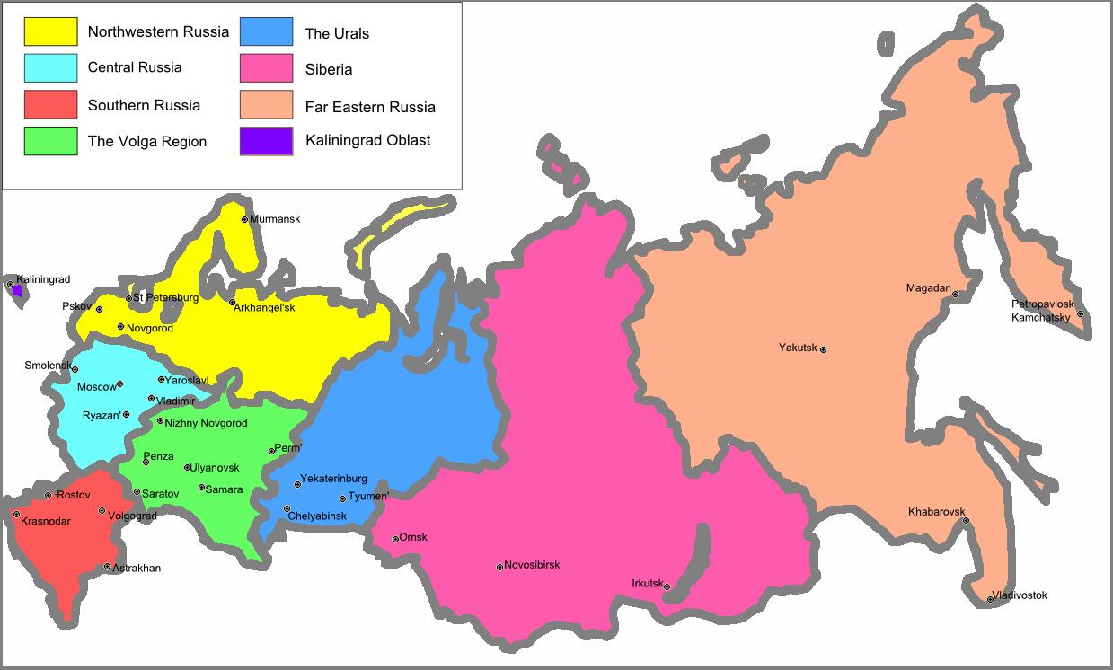
The seven administrative districts (okrug) of post-Soviet Russia
This is a post-1991 map.
The seven major administrative okrugs or Federal Districts (since 2010 there have been eight) into which Russia is today divided were also used in Soviet times to define the principal groups of Regions and Republics into which the army and the police divided the RSFSR.
Also listed here is the Kaliningrad Region (or oblast), formed after the war from captured and ethnically cleansed East Prussia.
*
Note that many city names have since reverted to their pre-revolutionary titles.
At the same time Sverdlovsk, again Yekaterinburg (Urals District or okrug), Gorky, again Nizhny Novgorod (Volga District or okrug), and Leningrad, again St Petersburg (Northwest District or okrug) are still surrounded, respectively, by the Sverdlovsk, Gorky and Leningrad Regions.
*
In the Soviet period the North Caucasus and its seven Autonomous SSRs were included within the South District. Today it constitutes the eighth administrative District (okrug) of Putin’s Russia.
*
4.2 : The SOVIET UNION (USSR)
Union of Soviet Socialist Republics (1922-1991)

The largest country in the world, its territory spread across eight differing time-zones
There have been changes in the post-Soviet names of certain capital cities. Frunze (capital of the Kyrgyz SSR) is Bishkek; the capital of Kazakhstan in Soviet times was Almaty.
Independent Ukraine calls its towns and cities by their Ukrainian names: for example, the capital is Kyiv (Kiev); two other major cities are Lviv and Kharkiv (Lvov and Kharkov). See “Letters and Statements” (CCE 22.10 [1]) for an early and interesting appraisal of unofficial Ukrainian and Russian attitudes to each other in the Soviet period.
*
4.3 : DUBROVLAG
Mordovian Camp Complex
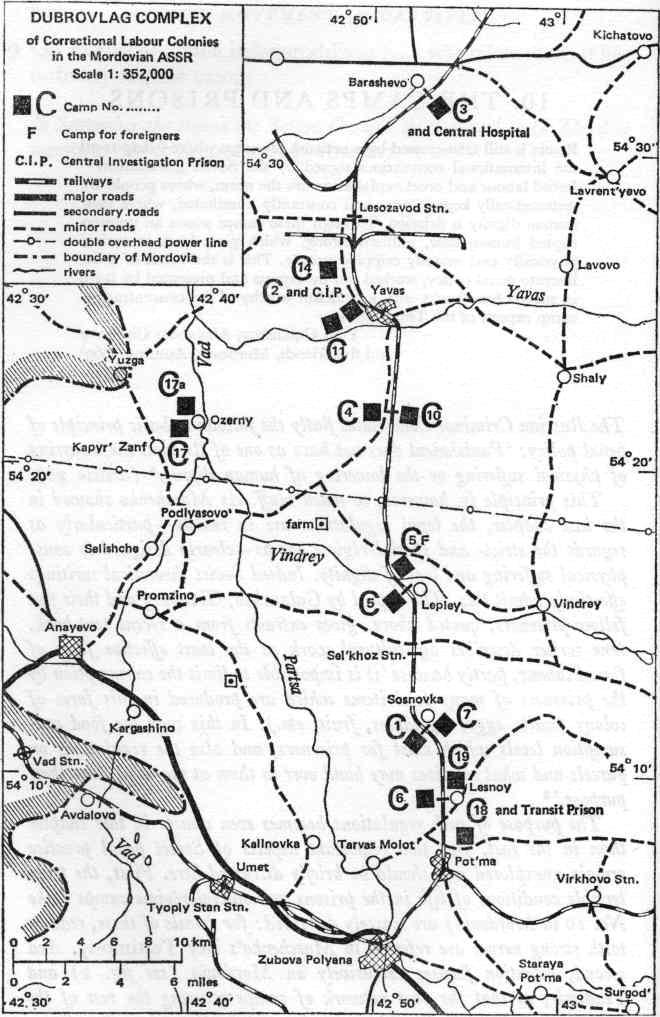
from Ferment in Ukraine (1971; ed. Michael Browne, p. 120)
This map shows the layout and organisation in 1969 of the 19 camps of Penal Institution ZhKh-385 (Dubrovlag). Until the Perm camps to the east came into use for politicals in the early 1970s (CCE 33.5-1, CCE 33.5-2) most convicted political prisoners (Articles 70 & 72) were held either in these camps (“Institution 385”) or Vladimir Prison in east-Central Russia, see Map 4.1 above.
(Those convicted under Article 190 served their sentence in ordinary camps for criminals.)
*
In the mid-1970s the Chronicle published a detailed description of the Mordovian complex (CCE 33.4): political prisoners were then held in Camps 1, 3, 17 and 19. The geographical description offered there largely corresponds to the layout shown on this map.
Mordovia forms part of the Volga District (okrug) of the RSFSR, see Map 4.1 above.
It abuts the Gorky Region with its million-strong capital city, again called Nizhny Novgorod (pop. 1, 170, 133; 1970). The administrative capital of the Mordovian Republic was, and remains, Saransk (pop. 190,575; 1970).
==================================
NOTES
=====================
